Drone Roof Inspections
15 January 2023
What Is a Drone Roof Inspection?
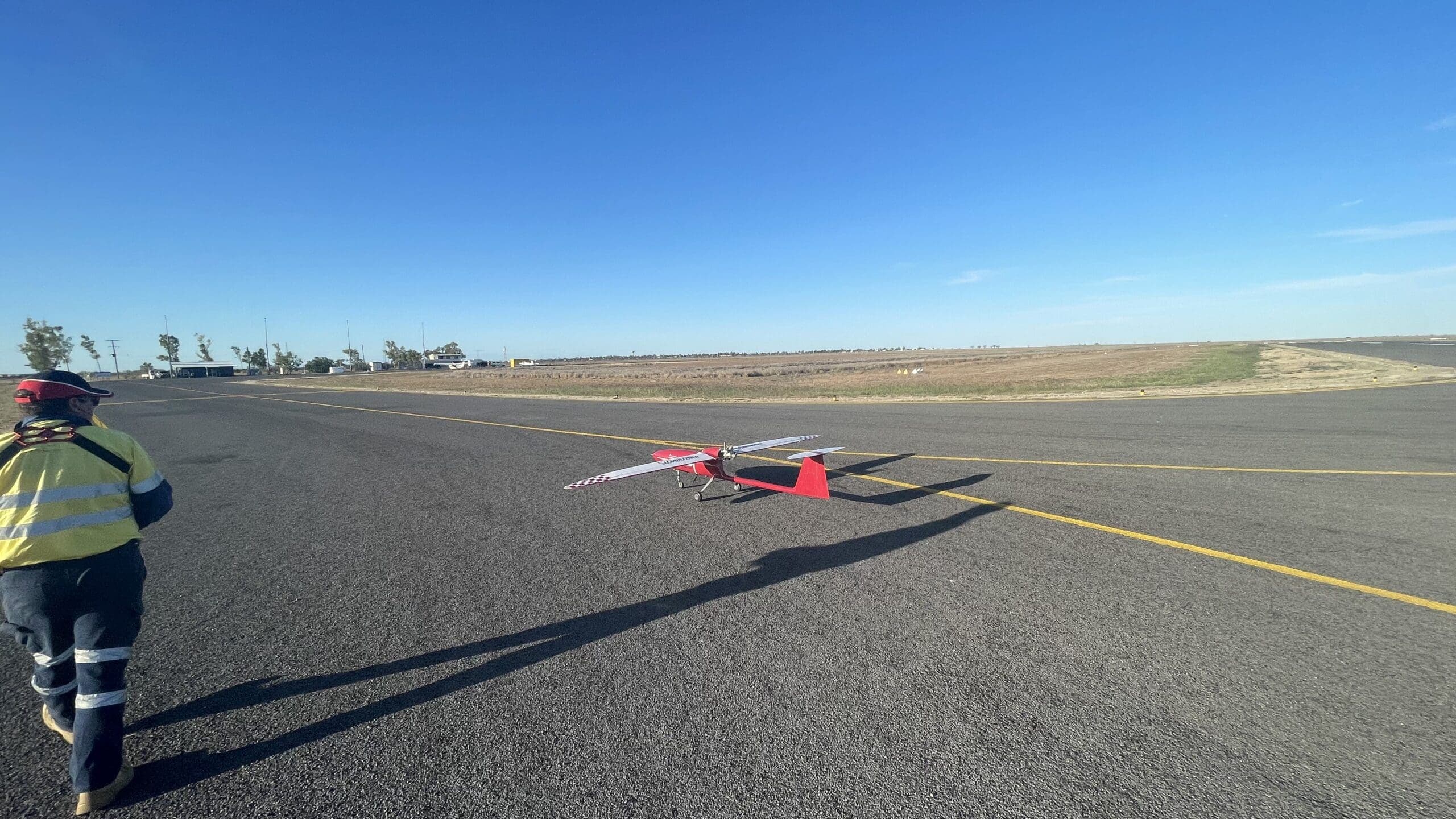
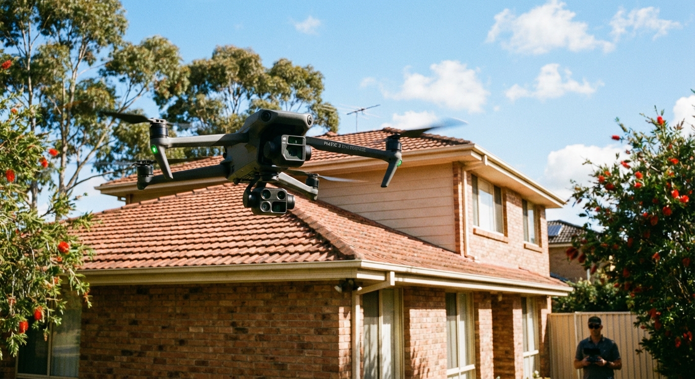
A drone roof inspection is a non-contact survey of a roof's condition using an uncrewed aircraft equipped with specialist cameras. Instead of sending a person onto the roof with a ladder and harness, a CASA-licensed pilot flies a drone over and around the structure, capturing high-resolution imagery that is later analysed and compiled into a detailed condition report.
Modern inspection drones carry two primary sensor types:
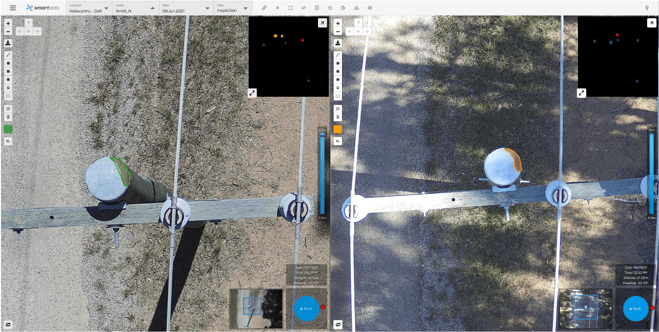
- RGB (visual) cameras — High-resolution cameras capturing 20+ megapixel images. These produce sharp, colour-accurate photographs that reveal cracked tiles, lifted flashing, blocked gutters, and surface deterioration with far greater detail than the naked eye from ground level.
- Thermal (infrared) cameras — Radiometric thermal sensors that measure surface temperature variations across the roof. Thermal imaging reveals problems hidden beneath the surface: trapped moisture, insulation failures, air leakage, and membrane defects that would be completely invisible during a traditional visual inspection.
By combining both sensor types in a single flight, a drone roof inspection delivers a comprehensive assessment of both visible and subsurface conditions — something no manual inspection can replicate without invasive testing.
When Do You Need a Drone Roof Inspection?
Roof inspections are not just for when something has already gone wrong. There are several scenarios where a drone inspection provides critical information.
Pre-Purchase Building Inspections
Before buying a property, understanding the true condition of the roof can save tens of thousands of dollars. A drone inspection gives buyers clear, documented evidence of the roof's state — cracked tiles, corroded flashing, ponding water — before they commit to a purchase. Building inspectors increasingly request drone data to supplement their reports.
Insurance Claims — Storm, Hail, and Wind Damage
After a severe weather event, drone imagery provides the objective, timestamped documentation that insurers need to process claims. Rather than relying on a single assessor's notes, the entire roof is captured in high resolution, creating an indisputable record. This speeds up claims processing and reduces disputes.
Routine Maintenance Programs
For property managers and facility operators, scheduled drone inspections create a longitudinal record of roof condition over time. Small problems — a cracked tile, early-stage corrosion — can be identified and addressed before they become expensive repairs. Regular inspections also satisfy compliance obligations for commercial buildings.
Strata and Body Corporate Assessments
Multi-unit residential buildings require periodic roof assessments as part of their maintenance schedules. Drone inspections are less disruptive to residents than traditional methods (no scaffolding, no workers walking overhead) and produce comprehensive documentation for body corporate records and capital works planning.
Post-Construction Quality Assurance
New builds and renovations benefit from an independent aerial survey to verify that roofing work has been completed to specification. Drone imagery can identify workmanship issues — poorly sealed penetrations, misaligned tiles, incomplete flashing — before the builder leaves site and warranty periods begin to run.
Heritage Building Assessment
Heritage-listed buildings often have fragile roofing materials that cannot safely support foot traffic. A drone inspection eliminates the risk of damaging irreplaceable materials while still delivering the detailed imagery needed for conservation planning.
What Can a Drone Detect?
Drone roof inspections can identify a wide range of defects across all common Australian roofing types — concrete and terracotta tiles, Colorbond and metal sheeting, slate, membrane, and flat roof systems.
Visual Defects (RGB Camera)
- Cracked, broken, or missing tiles and sheets — Even hairline cracks are visible at the resolutions captured by inspection drones
- Flashing failures — Lifted, corroded, or poorly sealed flashing around penetrations, edges, valleys, and ridgelines
- Gutter damage and blockage — Sagging gutters, debris accumulation, vegetation growth, and downpipe disconnections
- Ponding water — Standing water on flat roofs indicating drainage failures or structural deflection
- Moss, lichen, and algae growth — Surface degradation that accelerates material deterioration
- Rust and corrosion — Early-stage and advanced corrosion on metal roofing, fasteners, and flashings
- Deteriorated sealant — Failed sealant around skylights, vents, aerials, and other roof penetrations
- Structural deformation — Sagging ridge lines, uneven surfaces, and displacement indicating structural issues
- Solar panel damage — Cracked cells, displaced mounting hardware, and wiring deterioration on rooftop installations
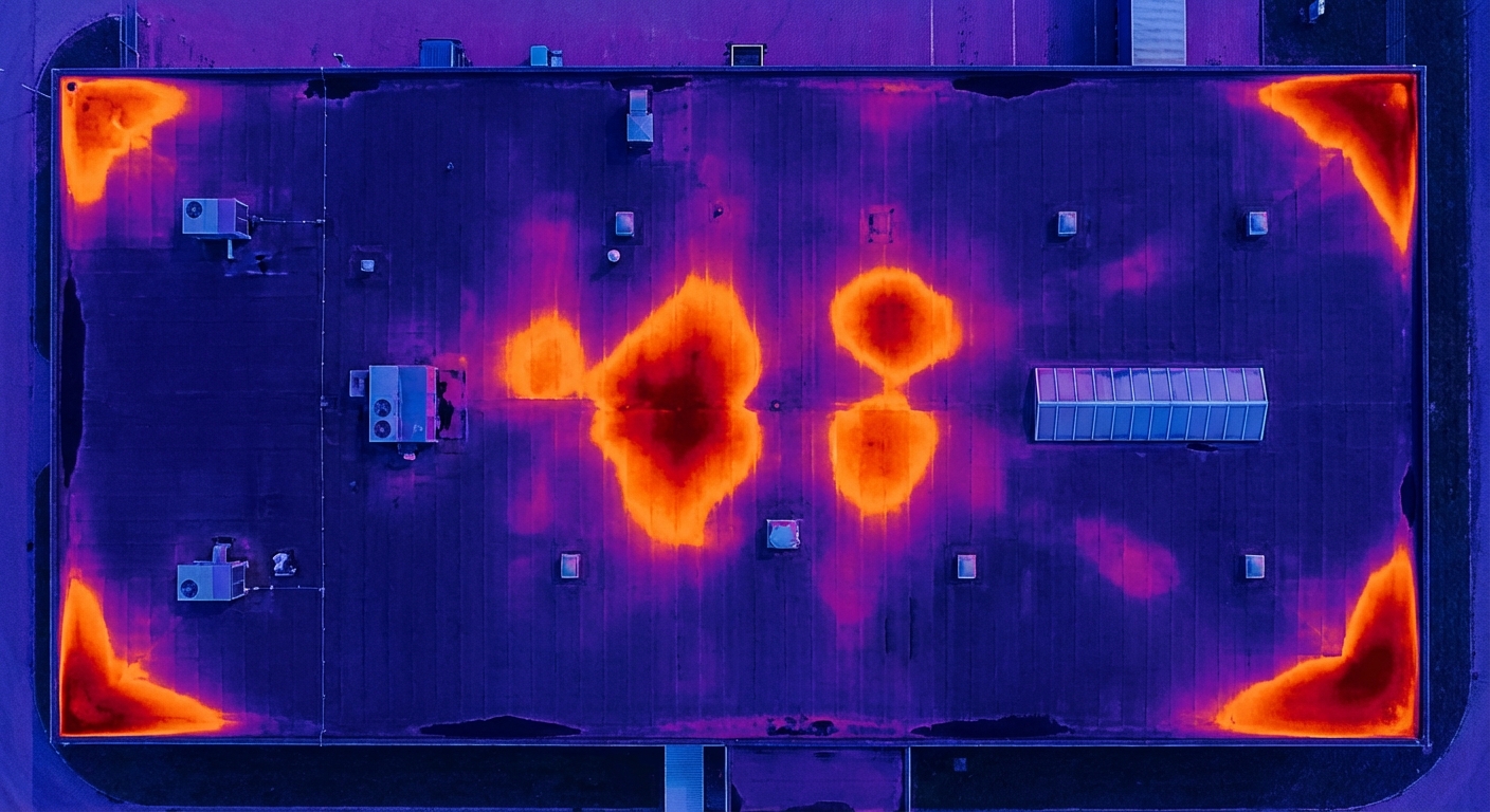
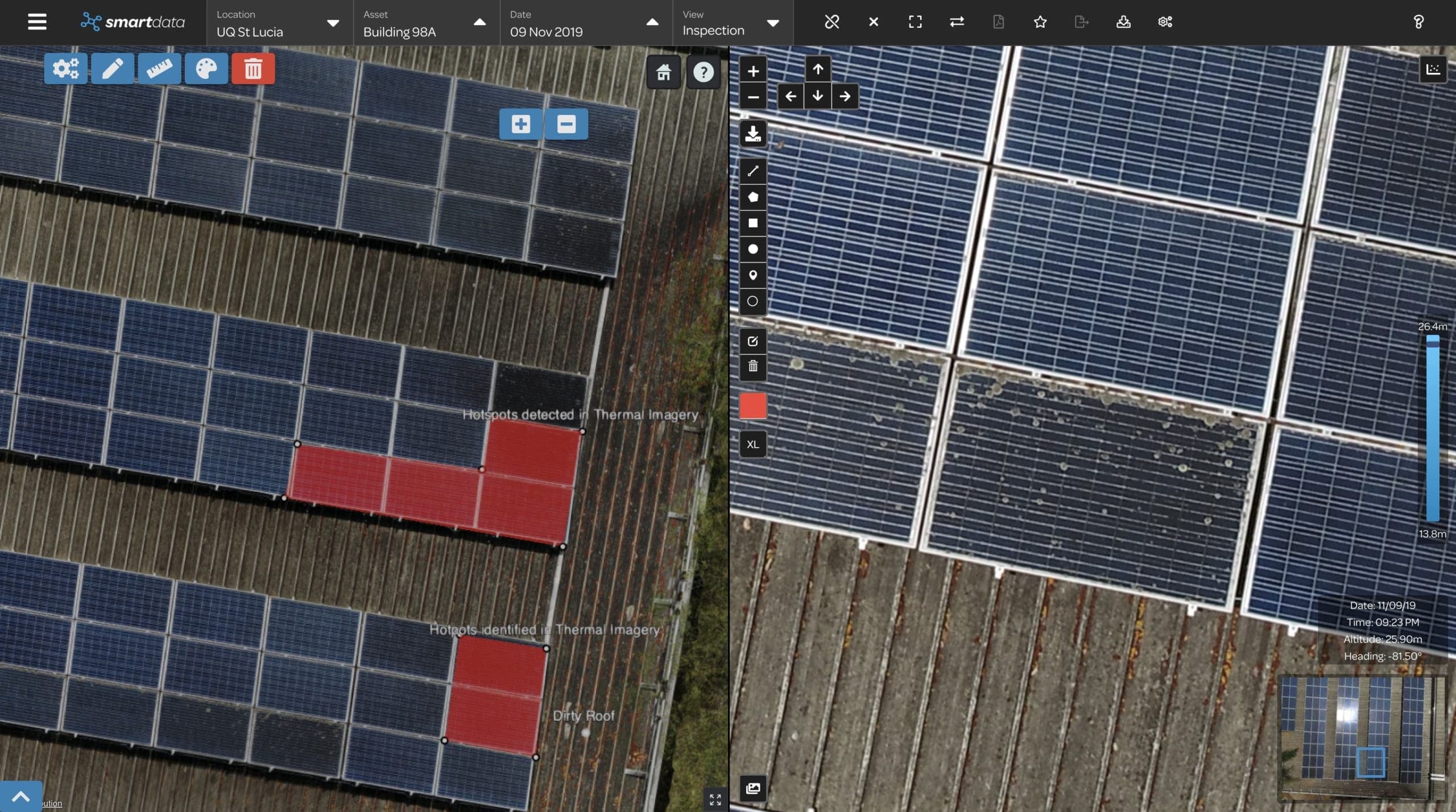
Subsurface Defects (Thermal Camera)
- Moisture ingress — Trapped water beneath roof membranes and within insulation, visible as cooler patches during the day or warmer patches at night
- Insulation gaps and failures — Missing or compressed insulation appears as distinct temperature anomalies on the thermal overlay
- Air leakage — Gaps around penetrations, joints, and edges where conditioned air escapes
- Membrane defects — Flat roof membrane failures that have allowed water to pool beneath the surface without any visible indication from above
Thermal inspections are particularly valuable for flat commercial roofs where moisture can accumulate beneath the membrane for months or years before causing visible damage.
How Drone Roof Inspections Work
Our inspection process follows a structured methodology that ensures consistent, thorough results regardless of building size or complexity.
1. Site Assessment and Flight Planning
Before the drone leaves the ground, our team reviews the property details, identifies any airspace restrictions (controlled airspace, nearby aerodromes, restricted areas), assesses potential hazards (power lines, trees, antennas), and plans the flight path to ensure complete coverage of the roof and all critical areas.
2. On-Site Briefing
Our CASA-licensed pilot arrives on site, conducts a final safety assessment of conditions (wind, weather, obstacles), and briefs any stakeholders present. Risk controls are confirmed and the flight area is secured.
3. Data Capture
The drone flies a systematic pattern over the roof, capturing overlapping high-resolution RGB imagery of the entire surface. For thermal inspections, a second pass (or simultaneous capture on dual-sensor aircraft) records infrared data across the roof. Critical areas such as penetrations, valleys, ridgelines, and edges receive additional close-range passes.
A standard residential roof requires 15–30 minutes of flight time. Large commercial buildings may require 1–2 hours depending on complexity.
4. Processing and Analysis
Back in the office, our team processes the captured imagery. For larger roofs, individual images are stitched into an orthomosaic — a geometrically corrected aerial map of the entire roof. Thermal data is overlaid and calibrated. Every image is reviewed and defects are identified, classified, and annotated.
5. Report Delivery
You receive a detailed inspection report including:
- Annotated high-resolution imagery with defects clearly marked
- Thermal overlays identifying subsurface anomalies (where applicable)
- A defect register with severity ratings and recommended actions
- An orthomosaic map of the full roof (for larger buildings)
- Executive summary suitable for stakeholders, insurers, or body corporate records
Reports are typically delivered within 2–5 business days of the inspection.
Drone vs Traditional Roof Inspections
The table below compares drone and traditional inspection methods across key criteria.
| Criteria | Drone Inspection | Traditional Inspection |
|---|---|---|
| Cost (residential) | $300–$500 | $1,000–$2,500 (with scaffolding/EWP) |
| Cost (commercial) | $800–$1,500 | $2,000–$5,000+ |
| Time on site | 30 minutes – 2 hours | 4 hours – 2 days |
| Safety risk | None (pilot stays on ground) | Falls from height, fragile surfaces |
| Thermal capability | Yes (standard add-on) | Requires separate specialist |
| Documentation | Complete photographic record | Written notes, limited photos |
| Disruption | Minimal | Scaffolding, restricted access, noise |
| Repeatability | Identical flight paths for comparison | Subjective, varies by inspector |
| Accessibility | Can reach any roof geometry | Limited by physical access |
Falls from height remain one of the leading causes of workplace injury and death in Australia. Every time a person climbs onto a roof, they are exposed to risk from the climb itself, unstable surfaces, fragile materials, and weather conditions. Drone inspections eliminate this risk entirely — the operator remains safely on the ground throughout.
Beyond safety, the documentation advantage is significant. A traditional inspection produces a written report based on what the inspector observed and noted at the time. A drone inspection produces hundreds of high-resolution images that can be revisited, zoomed into, and reanalysed at any point in the future. Nothing is missed because the inspector was looking elsewhere.
Industries Using Drone Roof Inspections
Property Management and Strata
Strata managers and property management firms use drone inspections to maintain portfolios of residential and commercial buildings. Scheduled inspections feed into maintenance planning and capital works budgets, with each inspection building on the documented history from previous surveys.
Education — Schools and Universities
Educational institutions manage large portfolios of buildings, many with ageing roofs. National Drones has conducted extensive roof inspection programs for organisations including Edith Cowan University and the NSW Department of Education, surveying dozens of buildings to prioritise maintenance and capital expenditure across campus facilities.
Government and Council Buildings
Local councils and government agencies are responsible for maintaining public buildings — libraries, community centres, depots, administrative offices. Drone inspections allow these organisations to assess entire building portfolios efficiently, directing limited maintenance budgets to the highest-priority repairs.
Commercial Real Estate
Commercial landlords and REITs use drone inspections to manage risk across office buildings, retail centres, and industrial properties. Thermal imaging is particularly valuable on large flat commercial roofs where membrane failures can go undetected for years.
Insurance Assessors
After storm events, insurance companies and loss adjusters use drone inspections to rapidly assess damage across many properties. The timestamped, geotagged imagery provides clear evidence for claims processing and can be revisited if disputes arise.
Deliverables — What You Receive
Every drone roof inspection produces a suite of deliverables tailored to the building type and the purpose of the inspection.
- Annotated orthomosaic — A high-resolution, geometrically accurate aerial map of the entire roof with defects marked and labelled. For larger buildings, this provides a single-image overview that is impossible to achieve from the ground.
- Thermal overlays — Calibrated infrared imagery showing temperature variations across the roof surface, with anomalies highlighted and interpreted. Moisture ingress, insulation failures, and membrane defects are clearly identified.
- Condition report — A structured report summarising findings, classifying defects by severity, and providing recommended actions and timeframes. This report is suitable for stakeholders, insurers, body corporate committees, and maintenance planning.
- Defect register — A tabulated list of all identified defects with location references, severity ratings, photographs, and recommended remediation. This feeds directly into maintenance management systems.
- Raw imagery archive — The complete set of high-resolution images captured during the inspection, available for independent review or future comparison.
All deliverables are provided digitally and can be shared with contractors, insurers, engineers, or other stakeholders as needed.
Getting Started
Whether you need a single residential roof inspected before purchase, a post-storm damage assessment for an insurance claim, or an ongoing inspection program for a portfolio of commercial properties, National Drones can help.
We operate across Australia with CASA-licensed pilots experienced in building and infrastructure inspections, including thermal imaging for subsurface defect detection.
Contact us to discuss your requirements and arrange a drone roof inspection.