LiDAR Drone Surveys
12 August 2023
LiDAR Drone Surveys
LiDAR (Light Detection and Ranging) is a remote sensing technology that uses laser pulses to measure distances and create highly accurate three-dimensional representations of the earth's surface and the features on it. When mounted on a drone, LiDAR becomes a fast, efficient, and cost-effective tool for capturing detailed survey data across a wide range of applications in Australia.
This guide explains how LiDAR works, when to use it versus photogrammetry, the deliverables it produces, and how drone LiDAR surveys are applied across forestry, mining, construction, power corridors, and infrastructure.
How LiDAR Works
A LiDAR sensor emits thousands of laser pulses per second toward the ground. Each pulse travels at the speed of light, reflects off surfaces it encounters, and returns to the sensor. By measuring the time between emission and return — known as time-of-flight — the system calculates the precise distance to each reflection point.
But distance alone is not enough. To convert these measurements into accurate 3D coordinates, the LiDAR system integrates three additional data sources:
- GNSS (GPS) positioning — provides the drone's precise location in three-dimensional space at any given moment
- Inertial Measurement Unit (IMU) — records the drone's exact orientation (pitch, roll, yaw) to account for movement during flight
- Encoder data — tracks the scan angle of the laser beam as it sweeps across the ground
By combining time-of-flight distance with the drone's position and orientation, the system calculates the exact X, Y, Z coordinate of every point where the laser reflected. Modern drone LiDAR systems emit 300,000 to over 1,000,000 pulses per second, building a dense three-dimensional point cloud of the survey area in a single flight.

Multiple Returns
Unlike photogrammetry, which can only see the outermost surface, LiDAR laser pulses can penetrate gaps in vegetation. A single laser pulse hitting a tree canopy may produce multiple returns:
- First return — the top of the tree canopy
- Intermediate returns — mid-story branches and understory vegetation
- Last return — the ground surface beneath
Modern sensors record up to 5 or more returns per pulse. By classifying these returns, analysts can separate canopy from ground, producing accurate bare-earth terrain models even in dense forest. This is LiDAR's single most important advantage over camera-based survey methods.
LiDAR vs Photogrammetry
Both LiDAR and photogrammetry (camera-based mapping) produce 3D point clouds and surface models, but they have fundamentally different strengths. Choosing the right technology — or combining them — depends on the project requirements.
| Factor | LiDAR | Photogrammetry |
|---|---|---|
| Vegetation penetration | Yes — multiple returns through canopy | No — sees only the outermost surface |
| Bare earth modelling | Excellent — classified ground returns | Poor in vegetated areas |
| Vertical accuracy | 2-5 cm with ground control | 3-10 cm depending on conditions |
| Visual output | Point cloud only (no colour by default) | Full colour orthophotos, textured 3D models |
| Light conditions | Works in any light (active sensor) | Requires good ambient light |
| Equipment cost | Higher (specialised sensor) | Lower (standard camera) |
| Processing | Point cloud classification, filtering | Image matching, dense reconstruction |
| Best for | Terrain under canopy, corridors, forestry | Open terrain, visual documentation, 3D models |
When to Use LiDAR
- Dense vegetation — LiDAR pulses penetrate tree canopy and understory to map the bare earth beneath. This is something photogrammetry simply cannot do.
- Low-light conditions — LiDAR is an active sensor that generates its own light. It does not rely on ambient illumination, making it effective in overcast, shaded, or dawn/dusk conditions.
- Bare earth extraction — when you need an accurate digital terrain model (DTM) of the ground surface, LiDAR's ability to classify ground returns is unmatched.
- High vertical accuracy — LiDAR typically achieves better vertical accuracy than photogrammetry, particularly in challenging terrain with slopes, cliffs, or dense ground cover.
- Corridor mapping — powerline, pipeline, road, and rail corridor surveys benefit from LiDAR's narrow swath coverage and ability to measure clearances to vegetation and structures.
When to Use Photogrammetry
- Visual context — photogrammetry produces high-resolution orthophotos and textured 3D models that provide the visual context LiDAR cannot.
- Cost-sensitive projects — photogrammetry equipment is less expensive than LiDAR sensors, making it more economical for projects where vegetation penetration is not required.
- Open terrain — in areas without dense vegetation, photogrammetry can achieve comparable accuracy at lower cost.
- Colour and texture — when the project requires visual documentation (construction progress, site records, marketing), photogrammetry delivers coloured outputs directly.
In many projects, the best approach is to combine both technologies — using LiDAR for accurate terrain data and photogrammetry for visual context. Our bridge inspection work with Aurecon combined LiDAR data capture with photogrammetry and 3D modelling to deliver comprehensive structural assessments.
LiDAR Survey Deliverables
Drone LiDAR surveys produce a range of deliverables depending on the project requirements. Understanding what each deliverable is and how it is used helps when specifying project scope.

Point Clouds
The primary output of any LiDAR survey is a classified 3D point cloud — millions of georeferenced points, each with X, Y, Z coordinates and a classification label (ground, vegetation, building, powerline, etc.). Point clouds can be viewed, measured, and analysed in specialist software and imported into CAD, GIS, and BIM platforms.
Digital Terrain Model (DTM)
A DTM represents the bare-earth surface with all vegetation, buildings, and other above-ground features removed. DTMs are used for engineering design, flood modelling, earthworks calculations, and any application that requires knowledge of the true ground surface.
Digital Surface Model (DSM)
A DSM represents the highest surface, including vegetation, buildings, and structures. The difference between DSM and DTM reveals the height of features above ground — useful for canopy height modelling, building height measurement, and obstruction analysis.
Contour Maps
Contour lines derived from the DTM at specified intervals (0.25m, 0.5m, 1m) provide the traditional topographic representation used in engineering design and planning applications.
Cross-Sections and Profiles
Longitudinal and cross-sectional profiles extracted from the point cloud or DTM are essential for road design, corridor assessment, and volumetric analysis. These can be generated at any location and orientation after the survey, without returning to site.
Volumetric Calculations
Cut-and-fill volumes, stockpile measurements, and material quantity calculations are derived directly from the LiDAR data. These calculations are used in mining, construction, and earthworks to track material movements and verify quantities.
Applications
Land Surveying and Engineering
LiDAR is used to produce topographic surveys, contour maps, and digital terrain models for engineering design, land development, and planning applications. The ability to survey through vegetation without clearing reduces project timelines and environmental impact.
Forestry
In forestry applications, LiDAR is the technology of choice for:
- Canopy height modelling — measuring tree height across entire plantations or native forest
- Timber volume estimation — combining canopy models with ground models to estimate standing timber
- Forest inventory and classification — distinguishing species, age classes, and stand density
- Fire fuel load assessment — measuring understorey density to predict fire behaviour
- Access road planning — designing extraction routes based on accurate terrain data
Mining
Mining companies across Australia use drone LiDAR for:
- Pit and dump surveys — high-accuracy surveys of active pits and waste dumps for reconciliation and compliance
- Stockpile volumes — precise volumetric measurements of material stockpiles for inventory management
- Monitoring subsidence and ground movement — detecting millimetre-level changes between survey epochs
- Earthworks planning and design — using DTMs for cut-and-fill calculations and haul road design
- Rehabilitation monitoring — tracking revegetation progress and landform stability over time
Our Olympic Dam survey for BHP and large-area survey for QEM demonstrate the scale at which drone surveys — including LiDAR — deliver value in mining and resource exploration.
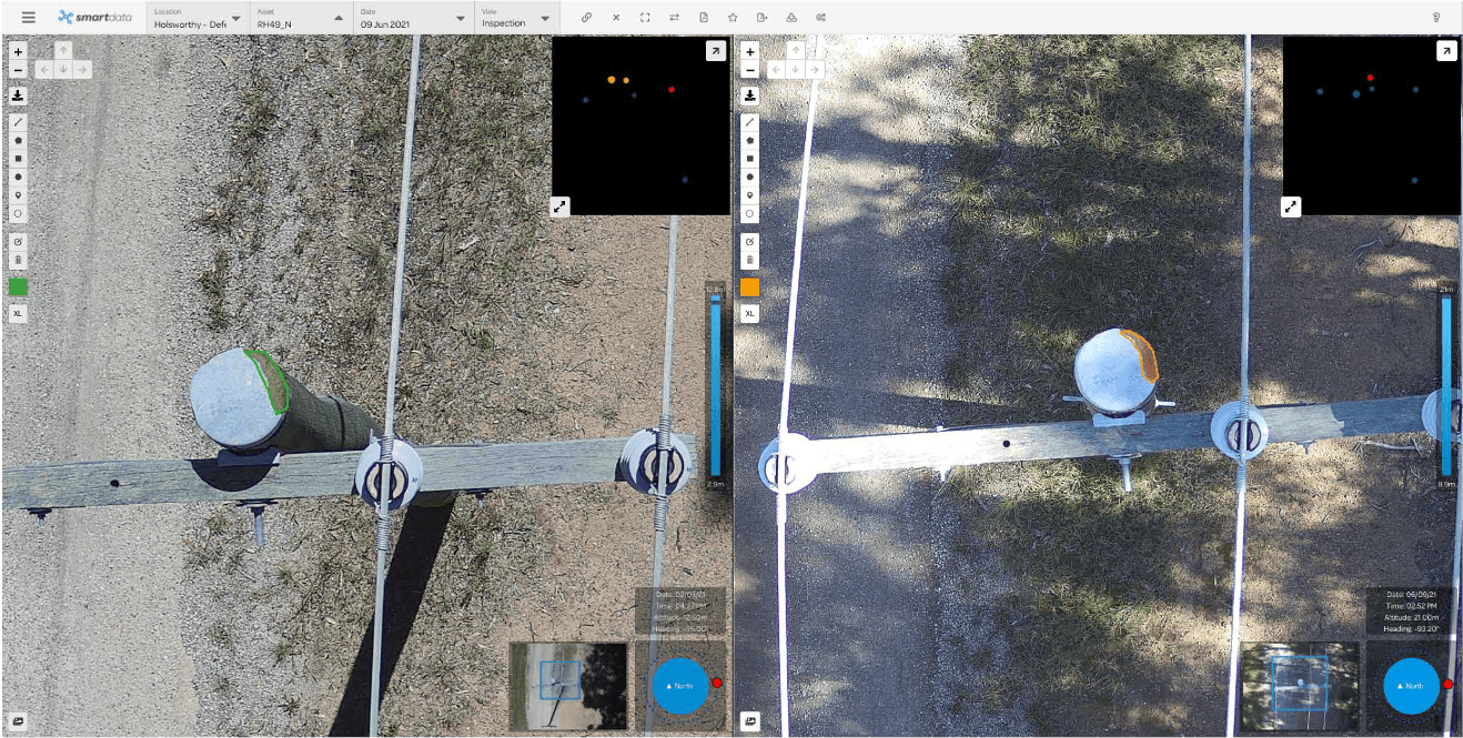
Power Corridor Assessment
LiDAR is the standard technology for powerline corridor surveys. The point cloud enables precise measurement of:
- Conductor clearances — distance from powerlines to ground, vegetation, and structures
- Vegetation encroachment — identifying trees and branches within clearance zones
- Structure condition — pole lean, crossarm deflection, and hardware condition
- Corridor profiles — longitudinal and cross-sectional profiles for engineering analysis
This data feeds directly into vegetation management programs and network planning. Combined with thermal inspection data, LiDAR provides a comprehensive picture of powerline network condition.
Construction
Construction projects use drone LiDAR for:
- Site surveys — accurate pre-construction topographic data for design and earthworks planning
- Progress monitoring — comparing as-built surfaces against design surfaces to track construction progress
- Volumetric verification — measuring cut-and-fill quantities for payment certification
- BIM integration — importing point cloud data into Building Information Models for clash detection and design validation
Archaeology and Cultural Heritage
LiDAR's ability to see through vegetation has made it a valuable tool for archaeological surveys, revealing features such as ancient structures, earthworks, and landscape modifications that are hidden beneath forest canopy. In Australia, this capability supports Indigenous cultural heritage surveys and environmental impact assessments.
Coastal and Environmental Monitoring
LiDAR supports environmental management through:
- Coastal erosion monitoring — measuring beach profiles and cliff recession between survey epochs
- Wetland and riparian zone mapping — accurate terrain data in areas where dense vegetation prevents other survey methods
- Habitat classification — using canopy structure data to classify vegetation communities
- Flood modelling — providing the terrain data essential for accurate hydraulic modelling
Our LiDAR Capabilities
National Drones operates drone-mounted LiDAR systems capable of surveying large areas with centimetre-level accuracy. Our systems capture dense point clouds with multiple returns, allowing us to produce accurate bare-earth models even in heavily vegetated areas.
Our LiDAR survey services include:
- Classified 3D point clouds (ground, vegetation, structures)
- Digital terrain models (DTM) and digital surface models (DSM)
- Contour maps at specified intervals
- Cross-sections and profiles
- Volumetric calculations
- Integration with existing survey data, coordinate systems, and BIM platforms
All data is delivered in industry-standard formats compatible with major CAD, GIS, and survey software packages.
Getting Started
If your project requires accurate terrain data, particularly in vegetated or difficult-to-access areas, a drone LiDAR survey may be the most effective solution. Contact National Drones to discuss your requirements and receive a quote. We operate across Australia with experience spanning mining, forestry, infrastructure, construction, and environmental management.
For a detailed breakdown of survey costs, see our drone inspection pricing guide.