The Importance of Thermal Drone Inspections
25 July 2023
The Importance of Thermal Drone Inspections
Thermal imaging technology, when combined with drone platforms, provides a powerful tool for detecting problems that are invisible to the naked eye. From identifying electrical faults on solar farms to locating heat loss in buildings, thermal drone inspections are becoming an essential part of asset management across multiple industries in Australia.
This guide explains how thermal drone inspections work, what they can detect, the types of thermal cameras used, and why organisations across energy, infrastructure, mining, and construction are making thermal drone inspections part of their standard maintenance programs.
How Thermal Drone Inspections Work
Thermal cameras detect infrared radiation emitted by objects and convert it into a visual image that represents temperature differences. Every object with a temperature above absolute zero emits infrared radiation, and the intensity of that radiation increases with temperature. A thermal camera measures this radiation and assigns colours to different temperature ranges, producing a thermogram that reveals heat patterns invisible to the human eye.
When mounted on a drone, these cameras can scan large areas quickly, capturing detailed thermal data from angles and heights that would be impossible to achieve from the ground. The drone flies a systematic pattern over the target asset while the thermal camera records radiometric data — meaning every pixel contains a precise temperature measurement, not just a colour.
This data is then processed to identify anomalies: hotspots that indicate electrical faults, cool patches that reveal moisture intrusion, or temperature gradients that expose insulation failures.

Types of Thermal Cameras Used in Drone Inspections
Not all thermal cameras are created equal. The type of camera used directly affects the quality and usefulness of the inspection data.
Radiometric vs Non-Radiometric
- Radiometric cameras record an absolute temperature value for every pixel in the image. This allows analysts to measure exact temperatures, set temperature thresholds, and compare data across inspections conducted at different times. Radiometric data is essential for professional inspections and is the standard used by National Drones.
- Non-radiometric cameras produce thermal images that show relative temperature differences but do not record precise temperature values. These are useful for quick visual assessments but are insufficient for professional inspection reporting.
Common Thermal Sensors for Drone Inspections
| Camera | Resolution | Thermal Sensitivity | Best For |
|---|---|---|---|
| DJI Zenmuse H20T | 640 x 512 | < 0.05°C | Multi-purpose inspections, dual visual+thermal |
| FLIR Vue Pro R | 640 x 512 | < 0.04°C | Dedicated radiometric surveys |
| DJI Zenmuse H30T | 1280 x 1024 | < 0.03°C | High-resolution industrial and solar inspections |
| Workswell WIRIS Pro | 640 x 512 | < 0.03°C | Scientific and research applications |
Higher resolution sensors produce more detailed thermograms, which is particularly important when inspecting small components such as individual solar cells or electrical connections. For large-scale inspections like solar farms or powerline corridors, resolution directly affects how many anomalies are detected.
Dual-Sensor Systems
Modern inspection drones typically carry dual-sensor payloads that capture both thermal and visual (RGB) imagery simultaneously. This is critical because a thermal anomaly alone does not always tell you what the problem is — the corresponding visual image provides the context needed to identify and classify the fault. For example, a hotspot on a powerline might be a failing connector, bird damage, or vegetation contact. The visual image clarifies which.
What Thermal Drone Inspections Can Detect
Thermal imaging reveals any condition that produces a temperature difference. In practice, this covers a wide range of faults and defects across different asset types.
Electrical Faults
- Overheating connections — loose, corroded, or undersized connections generate heat under load
- Unbalanced loads — phase imbalances in three-phase systems appear as temperature differences between conductors
- Failing components — transformers, capacitors, and switchgear approaching failure often run hotter than normal
- Cable damage — damaged or deteriorating insulation increases resistance and generates heat

Moisture and Water Ingress
- Trapped moisture in roofing — water beneath roof membranes retains heat differently to dry areas, creating clear thermal signatures
- Wall moisture — rising damp, leaking pipes, and condensation within wall cavities produce detectable temperature anomalies
- Flat roof defects — membrane failures where water has pooled beneath the surface without any visible indication from above
Insulation Failures
- Missing insulation — gaps in wall or ceiling insulation appear as distinct hot or cold patches depending on conditions
- Compressed or degraded insulation — insulation that has settled, been compressed, or degraded over time shows reduced thermal performance
- Thermal bridges — structural elements that conduct heat through the building envelope, bypassing insulation
Solar Panel Defects
- Cell hotspots — defective or damaged cells that overheat under load, potentially causing fire risk
- Bypass diode failures — failed diodes that reduce panel output and create hotspots
- String faults — entire rows of cells underperforming due to connection issues
- Junction box overheating — connection problems at the junction box
- PID (Potential Induced Degradation) — performance degradation visible as temperature patterns across affected modules
Mechanical Equipment
- Bearing failures — overheating bearings in motors, pumps, and conveyor systems
- Friction points — misaligned or worn mechanical components generating excess heat
- Pipe blockages — blocked or restricted flow in pipes creates temperature variations detectable from above
Industry Applications
Energy — Powerlines and Solar
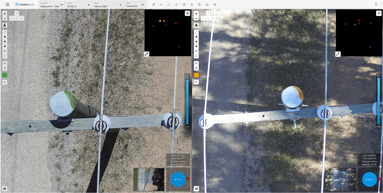
Thermal drone inspections are transforming maintenance for energy infrastructure. Utility companies use thermal drones to survey powerline networks at scale, identifying overheating connections, failing insulators, and vegetation encroachment before they cause outages or fires.
Our 25,000 power pole inspection program demonstrated how thermal and visual inspection data can be captured efficiently across large distribution networks, feeding directly into asset management systems.
For solar farms, thermal inspections are the primary method for identifying underperforming panels. A drone-mounted thermal camera can inspect thousands of panels in a single day, identifying faults that would be virtually impossible to find through visual inspection or electrical testing alone.
Water and Wastewater
Water utilities use thermal drone inspections to monitor treatment plants, reservoirs, and pipeline infrastructure. Our work with Gippsland Water included thermal imaging and NDVI analysis to assess asset conditions across their treatment facilities. Western Water similarly benefited from aerial surveys that combined photogrammetry with thermal data to provide comprehensive asset intelligence.
Thermal imaging can detect underground pipe leaks, identify seepage through dam walls, and monitor the temperature of discharge water — all from the air without disrupting operations.
Construction and Building Inspection
Thermal drone roof inspections are increasingly standard for commercial buildings. Thermal imaging reveals moisture ingress, insulation defects, and air leakage that visual inspection cannot detect. This is particularly valuable for:
- Pre-purchase building assessments
- Post-construction quality assurance
- Energy efficiency audits
- Routine maintenance programs for large building portfolios
Our inspections for Edith Cowan University and the NSW Department of Education included thermal data capture across dozens of buildings, enabling prioritised maintenance and capital expenditure planning.
Mining and Resources
In mining operations, thermal drones monitor:
- Stockpile temperatures — detecting spontaneous combustion risk in coal and other materials
- Haul road and embankment stability — heat anomalies indicating internal erosion or water seepage
- Tailings dam walls — seepage through dam walls that could indicate structural compromise
- Processing plant equipment — overheating motors, conveyors, and electrical systems
Firefighting and Emergency Response
Thermal drones play a critical role in bushfire response, providing real-time intelligence to incident management teams. Thermal imaging can:
- Identify hotspots and fire fronts through smoke that blocks visual cameras
- Locate spot fires ahead of the main fire front
- Guide search and rescue operations using body heat detection
- Monitor fire edges during mop-up operations to prevent re-ignition
Why Thermal Drone Inspections Are Superior to Ground-Based Methods
Coverage and Speed
A drone can inspect a large solar farm, building envelope, or powerline corridor in a fraction of the time it would take a ground-based crew. What might take a ground team a full week can often be completed by a drone in a single day, with better coverage and more consistent data quality.
Safety
Traditional thermal inspections often require workers to access elevated or hazardous locations such as rooftops, electrical substations, or industrial structures. Drones eliminate this risk entirely by capturing the same data from a safe distance. No scaffolding, no elevated work platforms, no rope access — the pilot operates safely from the ground.
Comprehensive Georeferenced Data
Thermal drone inspections produce georeferenced imagery that can be overlaid on maps, 3D models, or asset management systems. Every thermal anomaly is tied to a precise GPS location, making it straightforward to find and repair faults in the field. This also allows organisations to track the condition of their assets over time and make data-driven maintenance decisions.
Cost Efficiency
When you factor in the reduced time on site, eliminated access equipment, and improved fault detection rates, drone inspections are typically 40-70% cheaper than traditional thermal inspection methods for comparable or superior data quality.
Our Thermal Inspection Capabilities
National Drones operates a fleet of inspection drones equipped with industry-leading thermal cameras including the DJI Zenmuse H20T, H30T, and FLIR Vue Pro R. Our pilots are trained in thermal data acquisition techniques and understand the environmental factors — ambient temperature, wind speed, solar loading, time of day — that affect thermal data quality.
Every thermal inspection includes:
- Georeferenced radiometric thermal imagery
- Corresponding visual (RGB) imagery for context
- Anomaly identification, classification, and severity rating
- Temperature data analysis with comparison to operating baselines
- A detailed report with findings, location references, and recommended actions
We also integrate thermal data with other inspection methods including LiDAR, photogrammetry, and multispectral imaging to provide comprehensive asset intelligence.
Getting Started
If you need thermal drone inspections for your assets, contact National Drones to discuss your requirements. We service clients across Australia in energy, construction, mining, agriculture, water, and infrastructure. Whether it is a single building envelope scan or a multi-thousand-asset inspection program, our team has the experience and equipment to deliver actionable thermal data.